Lehi Planning Commission Work Session on Station Area Plans - March 6, 2025
STREAMING COPY IN PREPARATION — RECORDING AVAILABLE FROM THE ORIGINAL SOURCE
Lehi Planning Commission Work Session on Station Area Plans - March 6, 2025
The Lehi Planning Commission held a work session on March 6, 2025, to discuss two Station Area Plans: the North Lehi Station Area Plan and the Hospital/2100 North Station Area Plan. The meeting included presentations from consultants, followed by discussion and questions from commissioners. No formal votes were taken, but the commission provided feedback for further refinement.
Discussion Items
North Lehi Station Area Plan
- Consultant Christine Richman (GSBS Consulting) presented the plan, which is required by state statute for planned transit stations. The planning area includes the flight park, existing TOD under construction, single-family residential, a park, and trail infrastructure. Constraints include the Jordan Valley water line and hillside preservation ordinance. Key community engagement takeaways were concern about traffic and infrastructure capacity, desire for neighborhood-scaled amenities, and preservation of unique assets (e.g., flight park). The preferred scenario uses a 250-foot block grid to enhance walkability, with medium-density housing (townhomes, small single-family) at the core and more intensive mixed-use near the station. The plan envisions a village green, a village center near a proposed I-15 interchange, and a network of trails and bikeways. Implementation is phased: first (regulatory/funding), second (coordinate with track/station design), and third (post-station development). Approximately 200 of the 1,060 housing units are reserved for a future mixed-use development at the station.
- Commissioners asked about snow removal on narrower streets, connectivity to existing areas (e.g., Thanksgiving Point), and the mode of transit (light rail vs. BRT). The consultant clarified that the station is planned for light rail, with a circulator bus connecting to other areas.
Hospital/2100 North Station Area Plan
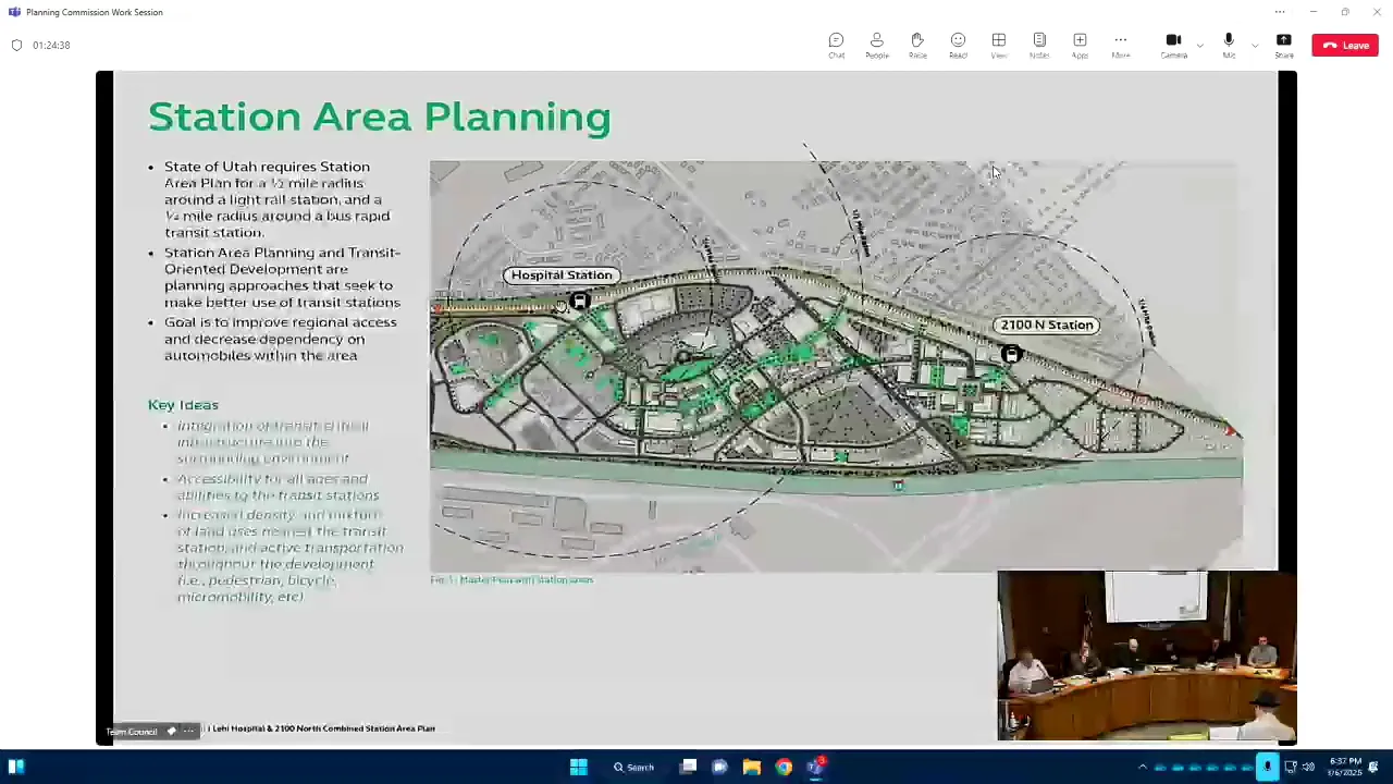
- Consultant Jordan Swain (Arcadis) presented the combined plan for two future stations: a light rail station at the hospital (South Triumph Station) and a BRT station further south (2100 North). The hospital station is expected to connect to the Point of the Mountain development and a future FrontRunner station. The BRT corridor would extend to Provo. The plan envisions a transit-oriented community with a strong multimodal spine (transit, multi-use path) and a "green loop" of open spaces. Land use districts include a health/wellness shopping center near the hospital, an innovation district, larger-format retail south of 1200 West, and lower-intensity residential toward established neighborhoods. A disentangled mobility network separates vehicular routes from a multi-use path. The plan recommends a park-and-ride structure near Young Living campus, contingent on negotiations between UTA and the landowner. Due to existing infrastructure constraints, no additional residential capacity is available north of 1200 West.
- Commissioners raised several concerns: the need for park-and-ride capacity to serve Lehigh residents east of I-15, connectivity between the two sides of the freeway, and the complexity of transferring between multiple transit modes (light rail, BRT, FrontRunner). Commissioner Greg expressed that the plan should consider the station as an origin for riders from other parts of Lehigh, not just a destination for nearby employees. Commissioner Brett emphasized the importance of preserving corridors for future connections and not creating isolated TOD nodes. Commissioner Mike noted ongoing regional planning efforts (Transit Fresh Look Study) that may address larger connectivity. The consultant acknowledged that while the plan focuses on the station area, broader connectivity will require coordination with UTA, UDOT, and city staff.
Key Outcomes
- No motions or votes were taken. The commission provided feedback for both plans, including requests to emphasize park-and-ride opportunities, improve east-west connectivity across I-15, and consider how the stations can serve a broader population.
- Next steps: The North Lehi Station Area Plan will have a public hearing at the next Planning Commission meeting (likely March 13, 2025), followed by review by the City Council and certification by Mountainlands Association of Governments. The Hospital/2100 North Station Area Plan will be presented again to the Planning Commission with additional implementation details before advancing to the City Council.
Meeting Transcript
Paging can uh don't hurry or anything. No, no, take your time. We serve at your pleasure. I got Uber someone, so good. I will. You ordered enough for the whole commission, right? And everybody that's here tonight. Nothing less. All right. Welcome to the March 6th edition of the Lehigh Planning Commission. Go ahead and call this to order. And uh let's let's dive right on in. North Lee High Station Area Plan presentation and discussion. Hi. Hello. How are you this evening? Doing well yourself? Good. Good. If you'd please state your name for the record. I am Christine Richman. I am a consultant with GSBS Consulting, and we were the team that led the North Lee High Station stationary planning process. So I'm here to present an overview of our findings and answer any initial questions that you might have tonight, very good. Okay. So we'll just dive right in. If I can get my mouse to work. So tonight we're going to do uh go through an overview of the report, which I think there was a version of it in your packets. Um review the planning process that we went through to identify the recommendations that are in the document and dig a little deeper into the preferred scenario and then talk about next steps, including the certification process that will come later with Mountainlands Association of Governments. First, I want to thank your staff and uh Mountain Lands Association of Government for the opportunity to work on this and to coordinate with them. We had a really good constructive process where there were a number of iterations that took into account a lot of the considerations that come into play for how we ended up uh with the preferred scenario that we do. So just a little bit about station area planning. You've probably heard this before because this is not your first station area plan, I know. Uh but the the stationary plans are required by state statute, and therefore existing and planned stations. This is a planned station. So that that comes into play a little bit when you see the implementation plan because we're talking about what to do over the next five years when you don't actually have uh that rail line doesn't exist and you don't have a station there. So you'll see that that implementation strategy is structured in a way to talk about things to do now while um that that line is in planning, things to do during construction, and things to do following construction of that line and creation of the actual stop. Um the purpose of station area planning is to identify a shared vision uh that's informed by existing uses and how that what the community's vision is for that area, and as a result, we have to we have a plan that identifies opportunities and constraints within the station area, identifies opportunities for affordable housing, identifies and describes the preferred vision, and then provides those strategic recommendations that are pursued uh not just by you, the city, but also by UTA and other local government uh uh government partners. So just some background. This is the planning area uh based on the radius around the the planned uh platform for the North Lee High Station, and you can see it takes in a lot of area that's already developed and uh areas that already have um constraints to them, if you will. So this particular area includes the flight park, the state flight park up on the hill above it, um, an entitled TOD that is under construction, existing single family residential, uh a park, your your new park is in this area, as well as some existing trail infrastructure. Another um constraint to uh this area of development is the Jordan Valley water line that you can see. Let's see if I can get this to do. No, it's not doing it. You can you can see there on the ditch next to I-15. Thank you. Yeah, yeah, right there. So that we can't build on that. We can have some pavement over that, but we can't uh put buildings on that, so we have to take that into account as we think about what the future of this area is. So when we put all of that together, uh you can see that the developable areas remaining are uh in ownership, uh including the city of Lehigh. That that includes the park and ride lot that will uh eventually be transferred to UDOT and UTA once this the line and the stop have been uh built, and then some areas of transit supportive development within that parking lot in a later phase of this uh of the vision.
openpublica.com