OPENPUBLICA · PUBLIC MEETING RECORD
Record of Proceedings
Rochester Planning Commission Meeting Summary - October 29, 2026
Boards and Commissions — Thursday, October 29, 2026
BodyRochester, Minnesota
SessionBoards and Commissions
DateThursday, October 29, 2026
StatusNEW · FILED
Video Record
STREAMING COPY IN PREPARATION — RECORDING AVAILABLE FROM THE ORIGINAL SOURCE
Transcript — Verbatim
Speaker numbers apply only to this recording. Names come from transcript evidence. “Possibly” marks uncertain attribution.
Discussion Breakdown — Share of Meeting
Parking20%
Zoning Regulations18%
Environmental Protection14%
Urban Design9%
Public Transportation9%
Homelessness9%
Procedural8%
Public Hearing8%
Public Comment3%
Summary of Proceedings
Rochester Planning Commission Meeting Summary - October 29, 2026
The Planning Commission met on October 29, 2026, to consider two major land use items: a preliminary plat for the Shannon Oaks 8th subdivision and a consolidated public hearing for a travel demand management plan and major modification to support a veteran housing project. The meeting included public comments, staff reports, and commission deliberation. Key votes included approval of the Shannon Oaks plat with conditions (3-2) and approval of the veteran housing parking reduction (4-1) and modification (5-0).
Consent Calendar
- Approved the September 16, 2026, meeting minutes unanimously.
- Approved the order of agenda, combining items 6A and 6B into one public hearing, unanimously.
Public Comments & Testimony
- Kelly Raykirkpatrick (1107 East Center Street) urged the commission to table the Shannon Oaks 8th plat pending a complete environmental record, including a wetland delineation and verification that grading would not require engineered mitigation. She emphasized the need for adequate technical evidence before approval.
- Andrew Inford (resident seven blocks from the veteran housing site) expressed support for the project's mission and infill density goals but raised concerns about parking adequacy given existing traffic and the nearby school.
- John Lovald (COO, Minnesota Assistance Council for Veterans) stated the project provides permanent supportive housing for veterans, with 90% of residents at or below 50% AMI and 15% vehicle ownership based on their statewide experience. He emphasized the nonprofit's commitment to maintaining the property and addressing issues.
- Ryan Schoenfeller (WSC, consultant) addressed parking concerns, noting availability of on-street parking, future multimodal investments (Link BRT), and a process for permit parking if needed. He explained that reducing parking further would cost housing units.
Discussion Items
Shannon Oaks 8th Preliminary Plat (Item 5A)
- Staff report (Desmond McGill, Community Development) : The 10.73-acre site (zoned R1) would be divided into 25 single-family lots. The wetland delineation from 2015 has expired; a new one is pending with the Soil and Water Conservation District. Staff recommended approval with five conditions, including wetland sequencing approval before final plat.
- Applicant (Mark Wells, GCUBE Engineering) : Presented a revised grading plan to reduce infrastructure costs and environmental impact. The wetland delineation was resubmitted; the incidental pond is not a permanent wetland. He confirmed no Decorah Edge features are present. The applicant agreed to the five conditions.
- Commission discussion : Concerns were raised about missing wetland documentation, tree removal, and community opposition. Commissioner Ross moved to table for more information, but legal counsel noted the 60-day statutory deadline and availability of an extension. After debate, the commission approved forwarding the plat to city council with the five conditions (vote 3-2: Ayes: Commissioner Ross (recused?), Commissioner Ixon, Commissioner Kroll; Nays: Commissioner Klein, Commissioner Boyham; Commissioner Ahmed abstained/arrived late).
Veteran Housing TDM & Major Modification (Items 6A & 6B)
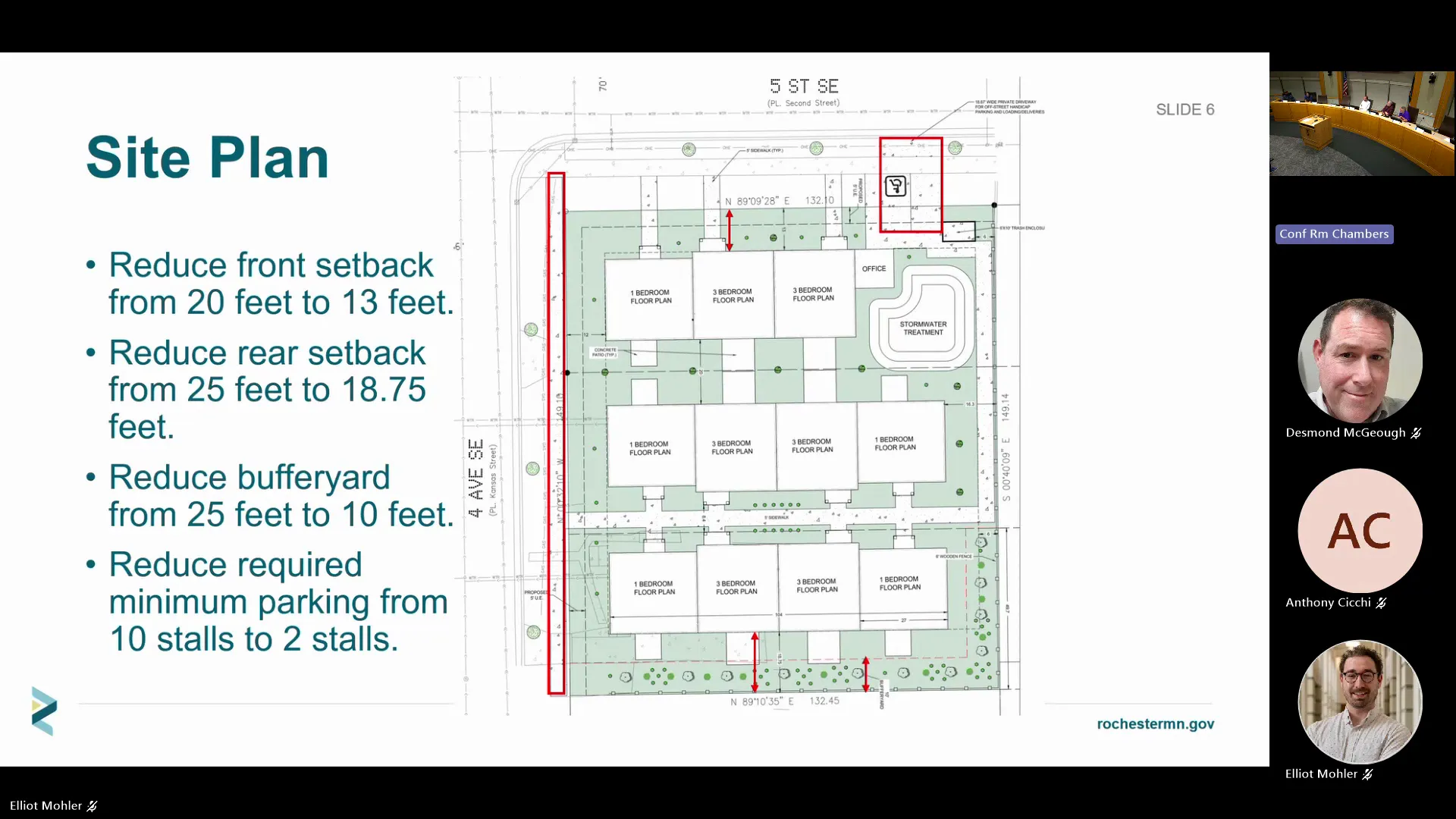
- Staff report (Elliott Miller, Community Development) : The project by Lenar/MACV at 5th St SE & 4th Ave SE seeks a travel demand management plan (reducing parking from 10 to 2 stalls) and a major modification (reducing front/rear setbacks and buffer yard). Staff recommended approval for both, citing transit access (frequent bus routes, future Link BRT), limited vehicle ownership among residents, and alignment with comprehensive plan goals.
- First vote on parking reduction : Motion to approve 2 stalls failed (2-3).
- Amended motion : After discussion of emergency access and precedent, the commission amended the parking reduction from 10 to 4 stalls. The new motion passed 4-1 (Ayes: Commissioners Ixon, Kroll, Boyham, Ahmed; Nay: Commissioner Klein; Commissioner Ross recused).
- Major modification vote : Motion to approve with the one condition (buffer yard plantings) passed unanimously (5-0).
Key Outcomes
- Shannon Oaks 8th Preliminary Plat (CD 2026-026) : Forwarded a recommendation of approval to the City Council with five conditions (wetland sequencing, grading/civil plans, parkland fees, boulevard trees) by a vote of 3-2.
- Travel Demand Management Plan (CD 2026-015 CUP) : Approved with a reduction from 10 to 4 parking stalls, tied to the MACV project, by a vote of 4-1.
- Major Modification (CD 2026-014 MOD) : Approved with one condition (full buffer yard plantings despite reduced width) by a vote of 5-0.
- Next Meeting : November 18, 2026. Adjourned.
Meeting Transcript
Evening, I'll call the meeting to order. We'll now begin with open common period. This is a time in the agenda that allows members of the public to address the commission on items not on tonight's agenda as a public hearing. If there's anyone listening that would like to address the commission, please do so at this time. And please introduce yourself. There we go. Hold it down. Good afternoon, Kelly Raykirkpatrick, 1107 East Center Street here in Rochester. Forgive my sunglasses, it's exceedingly bright in here for me. So I'm here to speak about Shannon Oaks 8th edition. I want to suggest that you table this particular plat due to a lack of, let's call it evidence, not against housing, but so that you are all informed as to the full capacity of the land. If you recall when I spoke last month, that was my object objective in our land practices and our necessity for housing, is that we shouldn't be working towards engineered mitigation to solve what we're trying to do, but instead work with the land to provide the housing that we need. So why table this particular plat? Mostly it's to defer for evidence and not against housing. And please complete request for a complete environmental record before the city advances this decision, as it may shape wetlands, groundwater drainage, and neighboring properties. The lots have been widened. We don't know why. Perhaps that can be answered. But the staff recommends the approval with five conditions. However, the site has earlier planning from 2019 that may or may not work with current regulations, and the layout has made some changes to adapt from that original 2019 preliminary plat. And prior planning approval is the most relevant context, but in and of itself, that is not the answer for ever for every current wetland and geological question. So whether the current record supports the findings that are needed now is what we're after. So wetland status must be documented, and we trust the city will do that, but it shouldn't be assumed. So one of the key pieces of the feature of this land is the incidental wetland. So finding out about that would be really helpful for you before you go forward to approve this andor direct the city council to approve it as well. So again, a complete wetland delineation, ask for that plat overlay on top of the wetland delineation, and get the exact conservation act, wetland conservation act information in your hands in your packet, so that you know what you're voting for. And then your local government unit is the common council to approve this. You are an advisory panel to the council. Please make sure that you are communicating with them and they understand everything that you are getting so that they can move forward as they need to as well. Desktop maps are great. We can all access them, but the sites are well known by the folks that have lived there. They've watched the geology change, they see where the rain goes and all of those other things, where the seeps are, decora edge may be exposed or not. And then you need to ensure that all of the grading and everything that's going to be done will not impact and require that engineered mitigation. It's not an assumption. We want to make sure that the impacts will occur and not require that mitigation. And why table instead of relying on the conditions that staff has shown you? Because you want to be able to view and make sure that those issues have been resolved before you give your approval, and your packet is not complete to be able to do that at this time. So these can be later later addressed if it is lawful. The city certainly won't do anything unlawful. However, it's important that you have all the information. So ask staff to identify which issues must be resolved now and which can be conditioned and the legal basis for that distinction. And then finally, it's the city's responsibility to demonstrate with adequate technical evidence and the required process that this layout protects wetlands. It protects our groundwater, which is so critical in a growing city right now, and the slope stability and neighboring properties. So again, this is not to say no to housing. This is to proceed with findings that identify what is satisfied and what remains outstanding. Thank you for your time. Are
SUMMARIZED BY OPENPUBLICA AI
TRANSCRIPT VIA PUBLIC VIDEO
openpublica.com
openpublica.com